Wednesday, January 26, 2011

Mount Kerinci

Mount Kerinci (also spelled Kerintji, among several other ways, and referred to as Gunung Kerinci, Gadang, Berapi Kurinci, Kerinchi, Korinci, or Peak of Indrapura as well) is the highest volcano in Indonesia, and the highest peak on the island of Sumatra. It is surrounded by the lush forest of Kerinci Seblat National Park, home to the endangered species of sumatran tiger and sumatran rhinoceros.

Geography
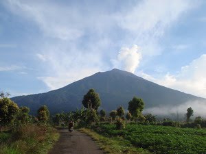
Kerinci is located in Province of Jambi, the west central part of the island, in the Pegunungan/Bukit Barisan, near the west coast, and is about 130 km (81 mi) south of Padang. It is the most prominent feature of the terrain of Kerinci Seblat National Park, with pine-forested slopes rising 2,400-3,300 metres above the surrounding basin, and a cone 13 km (8 mi) wide and 25 km (16 mi) long at the base, elongated in the north-south direction. At the summit there is a deep 600 m (1,969 ft) wide crater, often partially filled by a small crater lake on the northeast side of the crater floor.
View into the Kerinci crater.

Volcanic activity
Kerinci is more active than most Indonesian volcanoes, with nearly annual phreatic eruptions. Kerinci last erupted in 2004, and continues to spew clouds of sulphurous smoke, with plumes reaching as high as 1,000 m (3,281 ft) above the summit. While there is farmland in the area, and a tea plantation on its southern slope, Kerinci, being located in an Indonesian national park, and perhaps out of respect for its frequent growlings as well, sits in an area that is sparsely populated by Indonesian population-density standards.

Climbing
Kerinci can be climbed from the village of Kersik Tuo, 6 or 7 hours away from Padang by car or bus. The climb and descent normally takes 3 days and 2 nights, if you choose to go to the summit. You may also choose to go up only till Camp 2 or 2.5, skipping the summit attempt which is a night climb; and take 2 days and 1 night instead.

As of November 2007, the alert level for Kerinci was raised to Level 2- Orange, due to black smog seen coming out of the crater. But climbing the volcano is still relatively safe and allowed; though you may not climb any further than 1 km to the crater.

Kerinci's terrain consists of thick jungle, it can get muddy and slippery even if there are only mild drizzles, which may occur occasionally even during the dry season. To climb the volcano you need a guide, for there have been rare cases of people disappearing after attempting to trek alone.

Quoted from :http://en.wikipedia.org/wiki/Mount_Kerinci

Supported by : JavaTourism, Lintang Buana Tours

Mount Kaba

Kaba, a twin volcano with Mount Hitam, has an elongated summit crater complex dominated by three large historically active craters trending ENE from the summit to the upper NE flank. The SW-most crater of Gunung Kaba, Kawah Lama, is the largest. Most historical eruptions have affected only the summit region of the volcano. They mostly originated from the central summit craters, although the upper-NE flank crater Kawah Vogelsang also produced explosions during the 19th and 20th centuries. In 1833 an eruption ejected water from the crater lake, forming lahars that produced damage and fatalities at Talang, Klingi, and Bliti villages.

Quoted from :http://en.wikipedia.org/wiki/Kaba_%28volcano%29

Supported by : JavaTourism, Lintang Buana Tours

Sunday, January 23, 2011

Randai

Randai is a folk theater tradition of the Minangkabau ethnic group which incorporates music, singing, dance, drama and the silat martial art. Randai is usually performed for traditional ceremonies and festivals, and complex stories may span a number of nights.[1] It is performed as a theatre-in-the-round to achieve an equality and unity between audience members and the performers.[2] Randai performances are a synthesis of alternating martial arts dances, songs, and acted scenes. Stories are delivered by both the acting and the singing and are mostly based upon Minangkabau legends and folktales.[1] Randai originated early in the 20th century out of fusion of local martial arts, story-telling and other performance traditions.[3] Men originally played both the male and female characters in the story, but since the 1960s women have also participated.

Quoted from :http://en.wikipedia.org/wiki/Randai

Supported by : JavaTourism, Lintang Buana Tours

Balinese Caste System

The Balinese caste system is a system of social organization similar to the Indian caste system. However, India's caste system is far more complicated than Bali's, and there are only four Balinese castes.

The four castes of Bali are:
* Shudras - peasants making up more than 90% of Bali's population. They constitute close to 93% of the population.
* Wesias (Vaishyas) - the caste of merchants & administrative officials
* Satrias (Kshatriyas) - the warrior caste, it also included some nobility and kings
* Brahmins - holy men and priests

Note the similarity of the castes to the four varnas (shudra, vaishya, kshatriya, brahmin) of India.

The members of the four castes use different dialects of the Balinese language to address members of a different caste. Middle Balinese is generally used to speak to people whose caste is unknown in an encounter. Once the caste status of the participants are established, the proper language is used to address each other.

Nowadays, the caste system is used more in religious settings where the members of the lower caste would ask the members of the Brahman caste (the Pedandas) to conduct ceremonies. Since the Dutch colonial years and more recently after the Indonesian independence, the differences in the economic roles of the members of the caste system are slowly eroding as the government prohibits treatments based on the caste system.

Most of the Kshatriya families in Java and Bali became extinct during the fall of the Majapahit and the numerous Javanese wars. Almost all of the Balinese Kshatriyas trace their origin to the royal family of King Deva Agung, who ruled 500 years ago. Some of the original Kshatriyas, like those claiming descent from Arya Damar were relegated to Wesia status, so only those claiming descent from Deva Agung are recognized as proper Kshatriya in Bali.

During the 1950s and 1960s there were conflicts between supporters of the traditional caste system in Bali and its opponents. Many of the latter were affiliated with the PKI, the Communist Party of Indonesia, which was violently oppressed during the Indonesian killings of 1965–1966.

Quoted from :http://en.wikipedia.org/wiki/Balinese_caste_system

Supported by : JavaTourism, Lintang Buana Tours

Friday, January 21, 2011

Bubuhan Tinggi

Rumah Bubungan Tinggi or Rumah Banjar or Rumah Ba-anjung is an iconic type of house in South Kalimantan. Its name Bubungan Tinggi refers to the steep roof (45 degrees). In the old kingdom time, this house was the core building within a palace complex, where the King and his family resided. Since 1850, there were various buildings added around it with their own respective functions. Later this type of house became so popular, that people which were not part of the royalty also took interest in building it.

Today, there are houses of this type of architecture all over South Kalimantan, and even crossing the borders of Central Kalimantan and East Kalimantan. As it is more expensive than a usual house, it is only affordable for the more wealthy people.

Construction Elements
The main construction elements of the Rumah Bubungan Tinggi are:
* The main building part in the middle.
* Anjung, the constructions on the right (Anjung Kanan) and the left side (Anjung Kiwa) of the central part.
* The central part of the roof that is very steep, the Bubungan Tinggi.
* Front roof is Sindang Langit, rear roof is called Hambin Awan.

Rooms
* Palatar, the front room which is the first room someone would encounter after climbing the stairs
* Panampik Kacil, a small room after someone enters Lawang Hadapan (front door). The floor is higher than Palatar. This floor border is called Watun Sambutan.
* Panampik Tangah, a bigger room than Panampik Kacil, with a higher floor. The floor border is called Watun Jajakan.
* Panampik Basar or Ambin Sayup, the in oppose of the Tawing Halat (middle wall), with an even higher floor. The floor border is called the same thing with the Panampik Tangah, Watun Jajakan.
* Palidangan or Ambin Dalam, the inner part of the house which borders the Panampik Basar. The floor is the same height with Panampik Basar (but in some houses, the floor of Panampik Basar is lower than Palidangan’s). The border is called Watun Langkahan. In this room is the large pillars that hold the Bubungan Tinggi (there are 8 of them). These pillars are called Tihang Pitugur or Tihang Guru.
* Panampik Dalam or Panampik Bawah is a quite large room with floor lower than Palidangan’s and has the same height with Panampik Tangah. The border of this floor is called Watun Jajakan.
* Padapuran or Padu, the last room in the rear. The floor is lower than Panampik Bawah. The floor border is called Watun Juntaian. This part of the house is used for kitchening. Atangan part is the part for cooking, Salaian part is for drying the woods use for cooking, Pajijiban and Pagaduran are the parts for dishwashing and laundrying.

Quoted from :http://en.wikipedia.org/wiki/Bubungan_Tinggi

Supported by : JavaTourism, Lintang Buana Tours

The Newborn Baby Placenta Floating

The tradition rite of the newborn baby floating is an activity to make the rite habit, to treat and to free the placenta of the newborn baby from a spell. One of this placenta from a spell float the placenta that make a rite to sweep away the placenta of the newborn baby into the sea, it means the placenta become one in the water, in the future the baby can be hoped to have a wide perspective and getting a freedom so he could be up against and adjust to the environment. The series of this placenta floating activity was been first by the newborn baby, after the baby was born and was taken bath by the doctor, the baby's father washes out the placenta and after that it got in to the pot together with the symbolic things like salt, telon flower, note book, pen, Al-Qur'an of verces, needle, yarn and white cloth. After takes care the newborn baby, the baby's father recite call to prayer over the him/her and the placenta will be float into the sea. The activities procession of this placenta floating is beeing first by cucuking laku ( a kind of ceremonial dancing) and it is followed by the baby's father while bringing the placenta of the newborn baby and he is flanked by grand father and grand mother, together with the procession go to the sea and followed by a song of Mocopat Dandhang Gulo from the mothers After the activity of the floating is finished, they come back to shore, followed by the same song, then tumpeng, jenang sengkolo and other food have been prepared to eat together after having prayer. In the evening there is still an activity to show the happines for thye newborn baby with hadrah & rodath atraction, Surabaya lenggang dance and humoric stage.

Quoted from :http://www.surabayatourism.com/det_budaya.php?ID=16&lang=0

Supported by : JavaTourism, Lintang Buana Tours

Kempyang & Kethuk

The kempyang and ketuk are two instruments in the gamelan, generally played by the same player, and sometimes played by the same player as the kenong. They are important beat-keepers in the colotomic structure of the gamelan. Depending on the structure, they play different, repeating patterns every gongan. Not all structures use the kempyang, but the kempyang is never played without the ketuk.

They are shaped like bonang, but are generally placed in their own frame (rancak). The kempyang is pitched higher (about one octave, although it depends if they are in the pelog or slendro set. Both have a central boss like the bonang, but the kempyang has a rounder top (like the higher bonangs), while the ketuk has a flat top (like the lower bonangs).

In the common numerical notation, kempyang strokes are marked by "-" while the ketuk is marked by "+". The ketuk pattern is used to classify longer gendhing types, where it refers to the number of ketuk strokes in a nongan.

Quoted from :http://en.wikipedia.org/wiki/Ketuk

Supported by : JavaTourism, Lintang Buana Tours

Gong Ageng

The gong ageng is (Kromo Javanese meaning large gong, ngoko is gong gedhe). It is the largest of the bronze gongs in the Javanese and Balinese gamelan orchestra. Unlike the more famous Chinese or Turkish gongs, Indonesian gongs have fixed, focused pitch, and are dissimilar to the familiar crash cymbal sound. It is circular, with a conical, tapering base of diameter smaller than gong face, with a protruding polished boss where it is struck by a padded mallet. Gongs with diameter as large as 135 centimeters (54 inches) have been created in the past, but gongs larger than about 80 centimeters (32 inches) are more common especially to suit the budget of educational institutions.

The gong ageng is considered the most important instrument in a gamelan ensemble: the soul or spirit of the gamelan is said to live in it.

Gong ageng are often proffered ritual offerings of flowers, food and or and incense before performances to appease spirits believed to inhabit it.

Commonly, less expensive iron gong ageng or a slit-type gong are made to fulfill the role of the bronze gong, though at the loss of sound quality- for poorer regions and villages. The cost of expertly pure cast & beaten bronze has seen a rise in bronze-plated and bronze-laminated iron gongs for the undiscerning expatriate.

Quoted from :http://en.wikipedia.org/wiki/Gong_ageng

Supported by : JavaTourism, Lintang Buana Tours

Thursday, January 20, 2011

Sampit

Sampit town, on the Sampit River and the capital of Sampit regency, is known as the biggest timber port in Kalimantan as well as in Indonesia. Here can be found many sawmills, which process the timber for export. One can find many interesting tourism attractions in Sampit. Pandaran Beach is park on the seaside at the mouth of the Sampit River. It is quite unique. One sees to one's north the Orchid Park of “Pembuangan hulu” is a natural forest in which a number of rare and beautiful orchid varieties grow. Hunters can engage in their favorite pastime at the Serayan River, which borders on the hunting park of Kotawaringin Barat.

Quoted from :http://indonesia-tourism.com/central-kalimantan/kotawaringin_timur.html

Supported by : JavaTourism, Lintang Buana Tours

Way Kambas National Park

Way Kambas National Park is a large national park covering 1,300 square kilometres in Lampung province, south Sumatra, Indonesia.

Way Kambas consists of swamp forest and lowland rain forest, but was extensively logged before becoming a reserve in 1972 so there is little primary forest. The reserve still has a few Sumatran Tigers and reasonable numbers of elephants. It is also provides excellent birdwatching, with the rare White-winged Duck among the species present.

Another special feature of this national park is the Sumatran Rhinoceros still present in the area. Only 275 remain in South East Asia today. In Way Kambas a managed breeding center or Sumatran Rhino Sanctuary (SRS) has been build up in 1995. At this moment 5 Sumatran Rhinos live at the Sanctuary, most have been translocated from zoos to the large enclosures (with natural habitat) at the SRS.

Quoted from :http://en.wikipedia.org/wiki/Tesso_Nilo_National_Park

Supported by : JavaTourism, Lintang Buana Tours

Tuesday, January 18, 2011

Sabangau National Park

Sabangau National Park is national park in Central Kalimantan, a province of Indonesia in Kalimantan, the Indonesian part of the island of Borneo.

Geography
The national park is centered on Sabangau River, a blackwater river. It flows through the Kelompok Hutan Kahayan or Sabangau peat swamp forest (5,300 km2), between the Katingan and Kahayan rivers. The peat swamp forest is a dual ecosystem, with diverse tropical trees standing on a 10m - 12m layer of peat - partly decayed and waterlogged plant material - which in turn covers relatively infertile soil.
Orang Utan in Sabah, Borneo

The severely degraded eastern part of the forest, between the Sabangau and the Kayahan, is officially designated for agriculture. However, since the failure of the Mega Rice Project, which drained large areas of peat forest in an attempt to create rice paddies, no further efforts are being made to make it suitable for this purpose[1][2].

The forest has been damaged by legal and illegal forestry. There is no longer any continuous forest cover where Orangutans may cross the river. A satellite view shows a grid of logging roads throughout most of the forest.

However, the western part is now protected as either National Park or National Laboratory Research Area. A study of the area shows that the hydrological integrity of the forest has been maintained, and it is therefore ecologically resilient,[3] although since it is close to the regional capital Palangkaraya it remains at risk.

Ecology
The forest is home to the world’s largest Orangutan population, estimated at 6,910 individuals in 2003, and other rare or unique species. The total Agile Gibbon population in the Sabangau catchment is estimated to be in the tens of thousands, but is declining fast[4].

Vulnerable bird species include the Large Green Pigeon (Treron capellei) and possibly Storm's Stork (Ciconia stormi) and Lesser Adjutant (Leptoptilus javanicus)[5]. Efforts are underway to establish long-term ecological monitoring in the forest.

Quoted from :http://en.wikipedia.org/wiki/Kutai_National_Park

Supported by : JavaTourism, Lintang Buana Tours

Kutai National Park

Kutai National Park is a lowland national park located on the east coast of Borneo Island, in the East Kalimantan province of Indonesia, few minutes south of the equator.

Geography
The park is located north of the Mahakam river and includes several lakes: Danau Maau, Santan, Besar and Sirapan. It is adjacent to the towns of Bontang and Sangatta and 120 km north of the provincial capital Samarinda. There are several traditional Bugis settlements within the national park.[1]
Orangutan in the Kutai forest

The Kutai National Park extends over an area of 2,000 km², part of the former Kutai Game Reserve which has been protected since the 1970s. However this status did not prevent the logging of a third of the forest in subsequent years. In an attempt to prevent further deforestation the Kutai National Park was established in 1982. Nevertheless, the great Borneo fires of 1982/83 destroyed another 60% of the forest. Thus only 30% of the primary growth forest remains.

Ecology
The principal vegetation types include coastal mangrove forest, freshwater swamp forest and kerangas forest. There have been 900 species of vegetation identified in the park.

The park provides habitat to a wide range of mammals including orangutan, Malayan Sun Bear, Sambar deer, Banteng, Maroon Leaf Monkey, White-fronted Leaf Monkey, Hose's Leaf Monkey, Proboscis Monkey, Bornean Gibbon, Clouded Leopard, Black Flying Squirrel, Marbled Cat, Flat-headed Cat, Yellow-throated Marten, Otter Civet, and Smooth-coated Otter.

The number of orangutans was found to have decreased dramatically, from 600 recorded in 2004 to about 60 in 2009. However a survey conducted in 2010 identified over 2,000 orangutans to be inhabiting the park.

Quoted from :http://en.wikipedia.org/wiki/Kutai_National_Park

Supported by : JavaTourism, Lintang Buana Tours

Monday, January 17, 2011

Kapuas

Kualakapuas is the capital of the Kapuas regency, south of Palangkaraya, on the Kapuas River 40 kilometers from Banjarmasin. A well-known tourism attraction is ‘Telo’ Island, a fishing village and port. It is a pleasant location for recreation. For the adventurer, white water rafters and nature lovers, there is Gohong Rawai, which known for its beautiful and challenging rapids. The gold mines of Teweh and Batu Api, Rungan district, are also interesting places to be visited. In this region, gold mining is a major source of livelihood for the people, who pan for the valuable metal using the old traditional method. Gold mines are found in many places in Central Kalimantan.

Quoted from :http://indonesia-tourism.com/central-kalimantan/kapuas.html

Supported by : JavaTourism, Lintang Buana Tours

Bangkirai Lake Kereng

It is an exquisite lake and located across Sebangau River, in Kereng Bangkirai village 12 km from Palangkaraya toward south. For towards to the location we can apply vehicle of land only 15 minutes from common cab.

Quoted from :http://indonesia-tourism.com/central-kalimantan/palangkaraya.html

Supported by : JavaTourism, Lintang Buana Tours